 The
Physical Environment The
Physical Environment
The
Physical Environment The
Physical EnvironmentGeology
The evolution of organisms is closely linked to the evolution of their environment. The major historical event which influenced the evolution of the Antarctic environment was the splitting up of the ancient supercontinent of Gondwana (named after an ancient Indian tribe known as the Gonds in conjunction with wana, meaning land).
The oldest rocks are Precambrian (about 3,000 million years old) and similar to those in Australia, India, Africa and South America to which it was once joined. The Transantarctic Mountains were laid down on the sea floor some 740 million years ago (Precambrian) and subsequently uplifted and folded. By early Devonian times (350 million years ago) the early upfolded rock had been eroded to allow the sea to return and the subsequent deposition of sediments (now fossiliferous) occurred. Global cooling occurred during the late Carboniferous (300 million years ago) and early Permian times (240 million years ago) and the future Antarctica was under glaciers. The climate subsequently warmed and plant life became abundant in the later Permian forming what is now recognisable as coal seams. Volcanic activity increased during the Triassic (190 million years ago) and during the early Cretaceous (178 million years ago) Gondwana began to split up.
During the early Tertiary (45 million years ago) the Transantarctic Mountains began to uplift, the Ross Sea was formed, and increased vulcanism saw the deposition of many local landmarks. The development of the Transantarctic mountains led to the formation of the Dry Valleys with the disappearance of their glaciers. Subsequent developments have seen the shaping of the current landscape and the formation of soils from glacial-deposited till in ice-free areas. Salts (derived from weathering and precipitation) accumulate in the soils because there is little water to wash them away. Where moisture exists, the soils can support microorganisms, mosses, lichens, fungi and a few invertebrates such as springtails (Collembola).
The Splitting of Gondwana
The solid surface of the earth consists of a series of tectonic plates which can move relative to each other. These plates are added to by basaltic material from the mantle of the earth being extruded in mid-ocean ridges so that confluent plates are pushed into collision at their margins. The collision sites are known as subduction zones since one plate sinks under the other to return plate volcanic material back to the mantle. In early geological times, collision of tectonic plates led to the crumpling up of the ocean floor, examples of which can now be seen as folded mountain chains such as the Himalaya.
Movement of the tectonic plates over geological time (continental drift) has resulted in the continuous restructuring of the earth’s surface. Part of the drift process resulted in the splitting up of the ancient Gondwana supercontinent. The process began about 178 million years ago (early Jurassic) with the splitting of Antarctica from Africa, and ended about 96 million years ago (late Cretaceous) with the separation of Australia and New Zealand from Antarctica. Temperatures began to fall significantly around 35 million years ago as the continent drifted away from South America and Australasia. Bradshaw (1990) provides an excellent reference source for the early geologic history of Antarctica.
Question
Physics and Chemistry
The Ozone Hole
Ozone is a molecular form of oxygen containing 3 atoms (O3) instead of the normal two (O2). It is formed when an oxygen atom (the product of the breakdown of molecular oxygen by sunlight) combines with molecular oxygen:
(i) O2 + hv → O + O
(ii) O +O2 → O3
Although it is only a minor component of the atmosphere (0.0001%), ozone plays an important role in the upper atmosphere (the stratosphere, 15-50 km above the earth) protecting us from the damaging effects of ultraviolet radiation, particularly UV-B (280-320 nm). The amount of ozone in the atmosphere (recorded in Dobson units) can be measured by spectrophotometry. The ozone hole is defined as an area of the atmosphere where the ozone level is below 220 Dobson units. Prior to development of the ozone hole the atmosphere above Antarctica is around 275 Dobson units. The record low is 88 Dobson units recorded over the South Pole in 1993.
Damage to the ozone layer of the atmosphere was first reported by British scientists in 1985. They found that ozone over the Antarctic was significantly depleted during October resulting in what is known as the ozone hole. On average, the hole grew in size each year it was recorded until about 1994, when the increase began to level off. The ozone hole now spreads over about 26 x 106 km2, which is roughly the area of North America.
The increase in size of the ozone hole is due to the presence of synthetic chlorine-containing gases which are transported high into the stratosphere (especially over the South Pole in spring) where they are eventually broken down to yield a chlorine atom that promotes the destruction of ozone. Bromine also contributes to the breakdown of ozone.
(iii) O3 + Cl → O2 + ClO
When a free atom of oxygen collides with the chlorine monoxide, molecular oxygen is produced releasing the chlorine atom to attack more ozone:
(iv) O + ClO → O2 + Cl
In this way, one atom of chlorine can destroy about 100,000 molecules of ozone. This has led to the perturbation of the natural balance of ozone in the atmosphere.
The ozone hole disappears in the austral summer because the polar vortex which creates the spiralling of air over the South Pole in spring breaks down allowing ozone-rich air from other latitudes to mix with that in the polar region. The air within the polar vortex is very cold (about –80° C) and this allows polar stratospheric clouds to develop which are also crucial to ozone depletion since on their surfaces active chlorine is able to form from intermediate reservoir molecules. Obviously the chemistry of ozone depletion is far more complex than is summarised here.
Typical among the synthetic chlorine-containing gases are the chlorohydrofluorocarbons (CFCs) such as freon, which is used in refrigerators and air conditioning units. Because they are relatively stable compounds, the CFCs have been accumulating in the environment since they were first introduced. Even if all CFC and related chemical production was to cease immediately, it would still take until about 2050 AD before the ozone hole disappeared.
Excessive depletion of ozone in the atmosphere results in more ultraviolet radiation reaching the earth’s surface. High energy UV-B radiation is particularly damaging, capable of altering DNA leading to cancers such as malignant melanoma. UV-B can also damage proteins, and in plants it is capable of bleaching chlorophyll such that it no longer functions as an energy absorbing molecule for photosynthesis. Because UV-B can penetrate clear sea water to a depth of about 20 m it can also impact on the productivity of phytoplankton which are at the base of the marine food web.
It is thought that the ozone hole will remain roughly similar in size in the near future with a possible decrease in the next 30-50 years as chlorine levels in the atmosphere decline.
Aurora Australis
The aurora australis, or southern lights, arises from plasma (ionised gases) in the solar wind (a stream of plasma flowing out from the sun) penetrating the earth’s atmosphere and colliding with nitrogen and oxygen to emit green and red light respectively. The ions of the solar wind are concentrated at the polar regions along the earth’s magnetic field lines and thus auroras are seen predominantly in these localities. An aurora can generate up to 1013 watts of electricity providing enough light to read by.
Question
Geography
Antarctica as a Wilderness Region
The Antarctic continent including all the islands and ice shelves covers approximately 13,661,000 km2 in area. This is about 50x the area of New Zealand. The continental coastline measures about 17,968 km, and the Antarctic continental shelf covers about 4x 10⁶ km2 at a mean depth of 350 m (nearly twice that of other shelves). Antarctica is the highest continent in the world with an average height above sea level of 2500 m. The highest peak is Vinson Massif (4897 m). Antarctica is almost entirely covered by ice, with exposed rock accounting for only about 0.4% (48,310 km2) of the continent. The ice cap has an average thickness of about 2450 m, reaching to 4,776 m at its maximum. There are two active volcanoes in Antarctica, one on Deception Island (off the Antarctic Peninsula) and the other (Mt. Erebus) on Ross Island, and around 70 extinct ones. Mt. Erebus (3794 m) contains a permanent molten lava lake in the summit crater. The solidified basaltic lava of Mt. Erebus is known as kenyte.
The Dry Valleys
The region known as the Dry Valleys is only one of a number of lesser known "Antarctic deserts". It encompasses the Taylor, Wright and Victoria Valleys and occupies an area of about 2500 km2. Strong, dry winds (relative humidity <10%) sweep down the valleys from the polar plateau serving to keep the rocks bare of snow. Microorganisms, fungi, plants and invertebrates can only survive in the Dry Valleys where they can find moisture. An interesting adaptation involves organisms such as certain cyanobacteria, algae and lichens which can actually live and grow inside sandstone rocks of the Dry Valleys, where they form what are known as "endoliths". Numerous mummified seals (mostly crabeaters) and some mummified Adelie penguins are also found in the Dry Valleys. It is thought that these carcasses are of animals that became disoriented and headed inland instead of seaward, eventually to die of dehydration up to 40 km or so from the coast. The carcasses are freeze-dried in excellent condition by the climate in the Dry Valleys, but they eventually erode as the wind takes its toll.
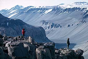
The Wright Valley.
Question
The Ice Sheets
The Antarctic ice sheet (or ice cap) is composed of the East (or Greater) and West (or Lesser) Antarctic ice sheets which effectively merge into one. The eastern sheet is larger, thicker and terrestrial, since it rests on a land base. The Transantarctic Mountains are on its western side (with reference to the Greenwich meridian). The western sheet is smaller, thinner and marine since its base is on the ocean floor. The Antarctic ice sheet covers about 99% of the continent extending over 14 x 106 km2 to a maximum depth of 4700 m. It contains about 30 X 106 km3 of ice and results from the continuous accumulation of snow which is packed down under its own weight to form dense glacial ice.
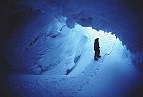
An ice cave which falls away to a crevasse on the right hand side.
The glacial ice sheet flows in ice streams under gravity towards the sea (at up to 1 km per year) where it forms ice shelves that float on the sea while retaining a connection with the ice sheet. Since the ice shelves float they are able to flow faster, at up to 3 km per year. The Ross Ice Shelf covers 490 x 103 km2 (nearly twice the size of New Zealand) and the Filchner-Ronne Ice Shelf about 449 x 103 km2.
At their margins the ice shelves break into tabular icebergs which drift off and eventually melt adding their fresh water to the sea. About 1450 km3 of icebergs are calved off the ice shelves each year and drift in the circumpolar currents at about 13 km per day. The largest iceberg ever recorded measured approximately 335 x 97 km which covers an area about half the size of Tasmania. Since about 80% of all of the world’s freshwater is contained within the Antarctic ice, icebergs represent a potential source of freshwater for the desert regions of the world. Although average-sized icebergs can last for 2 or more years (depending on their volume, shape and location) they are seldom found north of 55° S, however, because of the temperate waters.
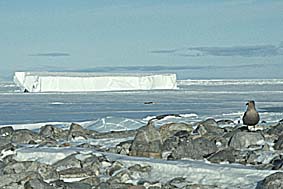
A tabular iceberg adrift in McMurdo Sound.
There is increasing concern that global (or local) climate changes resulting from the accumulation of greenhouse gases (e.g. carbon dioxide; nitrous oxide) could promote the melting of the ice shelves putting many countries at risk through rising sea water levels. Temperatures on the Antarctic Peninsula, for example, have risen 2.5° C since the 1940s. Over the last 100 years the global sea level has risen by between 10 and 25 cm. Although an unlikely event, if the entire Antarctic ice sheet were to melt, the sea level would rise by about 60 m.
The Ross Ice Shelf
The Ross Ice Shelf varies in thickness from over 1000 m where it is fed by glacial ice from the ice sheet to less than 100 m at the ice front. On its seaward side it calves icebergs at a rate of about 150 km3 per year, and it also loses volume by bottom melting at a rate of about 2.5 m per year. One of the largest icebergs recorded from the Ross Ice shelf in modern times appeared in the spring of 1987 and measured about 154 km long x 35 km wide.
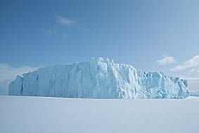
A grounded iceberg off Ross Island.
Sea Ice
The sea around the ice shelves is often frozen to form 2m thick sea ice which can extend from 4 x 10⁶ km2 in late summer (February) to 22 x 106 km2 before the thaw begins (September). The sea ice forms an insulating blanket over the sea and restricts light penetration which slows the growth of marine phytoplankton.
Drilling through the sea ice
(over 1 m thick)
in Winter Quarters Bay where Scott anchored
the Discovery when overwintering on his first
expedition.
The formation of sea ice is an annual phenomenon although some parts do not melt during the following summer. It begins with the freezing of the sea surface and the formation of "frazil ice" which later becomes slushy "grease ice". The patches of grease ice consolidate into loosely packed, flat, round plates known as "pancake ice". These thicken and coalesce to form larger slabs or floes which merge to form a solid sheet ("pack ice").
Frazil ice can also form in the water column giving rise to ice crystals and larger platelets (10-15 cm diameter) which float up and accumulate on the undersurface of the sea ice where they form "platelet ice". In shallow water, ice can form on both the upper and lower surfaces, the latter giving rise to what is known as "anchor ice".
Sea ice begins to form in the Ross Sea in March/April and is usually dispersed by mid summer to leave open water again, except where pockets of fast ice remain in bays and inlets. Pockets of open water (polynas) persist throughout the winter in a number of locations.
Question
Sub-glacial Lakes
A huge lake covering some 14,000 km2 land reaching 670 m in depth lies underneath the East Antarctic ice sheet in the vicinity of the Vostok research station. This lake, known as Lake Vostok, is one of 70 sub-glacial lakes on the continent. They are thought to form when the temperature beneath the ice sheet reaches melting point (about -1.5° C), probably as a result of the friction generated as the ice moves over the land mass under immense pressure. Because Lake Vostok is so large the ice sheet floats on it presenting a flat surface that enabled it to be mapped from space by satellite.
An attempt to drill through the ice sheet began in 1989, but was stopped in 1998 about 120 m above the lake surface (at a depth of 3623 m) to allow scientists to consider the consequences of breaching. Studies of the ice core showed it to be about 500,000 years old at this depth. Viable microorganisms have been isolated from parts of the ice core estimated to be 200,000 years old raising the possibility that the lake and its contents may provide information relevant to life in extreme environments such as that which existed when life first evolved. Unfortunately, most of this information can only be tapped by penetrating the lake itself. This presents significant problems since once the lake is penetrated contamination of its waters is inevitable. Ice drilling, for example, is enhanced by the use of a drilling fluid (the Russians typically use a mixture of aviation fuel and freon) with significant potential to contaminate the lake. Clearly, considerable thought is required before any strategy to penetrate the roof of the sub-glacial lake is put in place.
Question
Climate
Temperature
The Russian base at Vostok (78.5° S, 106.9° E), which is 3488 m above sea level, is the coldest place on earth with a mean annual temperature of around –55° C. The coldest recorded temperature at Vostok was –91° C in 1997. This is far colder than dry ice, which has a temperature around -70° C. The South Pole (90° S), which is at 2,835 m, has a mean annual temperature of about –49° C.
Why is Antarctica so Cold?
Wind
Cape Denison, the "home of the blizzard" where Douglas Mawson built his hut in 1912 is probably the windiest place on earth. During one spectacular and persistent hurricane Mawson recorded "a terrific series of Herculean gusts..... in the order of 200 mph" (320 km h-1). The highest recorded wind velocity is 327 km h-1 which was measured at the French base of Dumont d’Urville in July 1972.
Why is Antarctica so Windy?
The powerful gusts which caused Mawson so much trouble are the result of katabatic winds (from the Greek katabasis, going down) which arise when cold, dense air lying less than a few hundred metres off the surface at the highest levels of the Antarctic ice sheets flows down towards the coast under gravity. Near the coast these winds can reach the tremendous speeds Mawson experienced, in some places averaging over 70 km h-1 for the year. The onset of a katabatic wind is very rapid, it seems "to come from nowhere" and can disappear equally as fast. A temperature increase is usually associated with the arrival of a katabatic wind due to the sweeping away of the cold air layer that forms under calm conditions.
Question
Whiteouts
Whiteouts usually occur in overcast conditions over a snow-covered
surface. The illumination needs to be uniformly diffuse such that
shadows are not apparent and surface and horizon definitions are
lacking. Because shadows are not cast, snow covered topographic
features are not evident. This leads to poor judgment of distance
and difficulties in orientation which can have disastrous
consequences.